


Marine sediment cores database for the Mediterranean Basin: a tool for past climatic and environmental studies
Alberico I., I. Giliberti, D.D. Insinga, P. Petrosino, M. Vallefuoco, F. Lirer, S. Bonomo , A. Cascella, E. Anzalone, R. Barra, E. Marsella, L. Ferraro (2017).
Open Geosciences, 9/1, 221-239, doi: 10.1515/geo-2017-0019.
Abstract
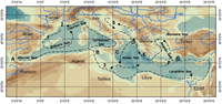
Paleoclimatic data are essential for fingerprinting the climate of the earth before the advent of modern recording instruments. They enable us to recognize past climatic events and predict future trends. Within this framework, a conceptual and logical model was drawn to physically implement a paleoclimatic database named WDB-Paleo that includes the paleoclimatic proxies data of marine sediment cores of the Mediterranean Basin. Twenty entities were defined to record four main categories of data: a) the features of oceanographic cruises and cores (metadata); b) the presence/absence of paleoclimatic proxies pulled from about 200 scientific papers; c) the quantitative analysis of planktonic and benthonic foraminifera, pollen, calcareous nannoplankton, magnetic susceptibility, stable isotopes, radionuclides values of about 14 cores recovered by Institute for Coastal Marine Environment (IAMC) of Italian National Research Council (CNR) in the framework of several past research projects; d) specific entities recording quantitative data on δ18O, AMS 14C (Accelerator Mass Spectrometry) and tephra layers available in scientific papers. Published data concerning paleoclimatic proxies in the Mediterranean Basin are recorded only for 400 out of 6000 cores retrieved in the area and they show a very irregular geographical distribution. Moreover, the data availability decreases when a constrained time interval is investigated or more than one proxy is required. We present three applications of WDB-Paleo for the Younger Dryas (YD) paleoclimatic event at Mediterranean scale and point out the potentiality of this tool for integrated stratigraphy studies.
https://www.degruyter.com/view/j/geo.2017.9.issue-1/geo-2017-0019/geo-2017-0019.xml?rskey=bZ5G2x&result=1&q=cascella