


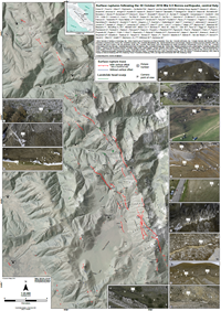
Surface ruptures following the 30 October 2016 Mw 6.5 Norcia earthquake, central Italy
Civico R., S. Pucci, F. Villani, L. Pizzimenti, P. M. De Martini, R. Nappi & the Open EMERGEO Working Group (2018).
Journal of Maps, 14/2, 151-160, doi: 10.1080/17445647.2018.1441756
Abstract
We present a 1:25,000 scale map of the coseismic surface ruptures following the 30 October 2016 Mw 6.5 Norcia normal-faulting earthquake, central Italy. Detailed rupture mapping is based on almost 11,000 oblique photographs taken from helicopter flights, that has been verified and integrated with field data (>7000 measurements). Thanks to the common efforts of the Open EMERGEO Working Group (130 people, 25 research institutions and universities from Europe), we were able to document a complex surface faulting pattern with a dominant strike of N135°-160° (SW-dipping) and a subordinate strike of N320°-345° (NE-dipping) along about 28 km of the active Mt. Vettore–Mt. Bove fault system. Geometric and kinematic characteristics of the rupture were observed and recorded along closely spaced, parallel or subparallel, overlapping or step-like synthetic and antithetic fault splays of the activated fault systems, comprising a total surface rupture length of approximately 46 km when all ruptures were considered.