


Visualization and comparison of DEM-derived parameters. Application to volcanic areas
Favalli M., A. Fornaciai (2017).
Geomorphology, 290, 69-84, https://doi.org/10.1016/j.geomorph.2017.02.029.
Abstract
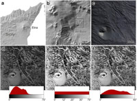
Digital Elevation Models (DEMs) are fruitfully used in volcanology as the topographic base for mapping and quantifying volcanic landforms. The increasing availability of free topographic data on the web, decreasing production costs for high-accuracy data and advances in computer technology, has triggered rapid growth of the number of DEM users in the volcanological community. DEMs are often visualized only as hill-shaded maps, and while this is among the major advantages in using them, the possibility of deriving a very large number of parameters from a single grid of elevation data makes DEMs a powerful tool for morphometric analysis. However, many of these parameters have almost the same informative content, and before starting to elaborate topographic data it is recommended to know a-priori what parameters best visualize the investigated landform, and therefore what is necessary and what is redundant. In this work, we review a number of analytical procedures used to parameterize and represent DEMs. A LIDAR-derived DEM matrix acquired over the Valle del Bove valley, on Mt. Etna, is used as test-case elevation data for deriving the parameters. We first review well known parameters such as hill-shading, slope and aspect, curvature, and roughness, before extending the review to some less common parameters such as Sky View Factor (SVF), openness, and Red Relief Image Maps (RRIM). For each parameter a description is given emphasizing how it can be used for identifying and delimiting specific volcanic elements. The analyzed surface parameters are then cross-compared in order to infer which of them is most uncorrelated, and the results are represented in the form of a correlation matrix. Finally, the reviewed DEM-derived parameters and the correlation matrix are used for analyzing the volcanic landforms of two case studies: Michoacán-Guanajuato volcanic field and a phonolitic lava flow at the Island of Tenerife.
https://www.sciencedirect.com/science/article/pii/S0169555X1630304X