


Simulated scenarios of volcanic mass movements and associated tsunamis at Stromboli (Aeolian archipelago, Tyrrhenian sea, Italy) – version 2, simulations with 20-m resolution topo-bathymetry
Creative commons license: Attribution 4.0 International (CC BY 4.0)
Mattia de’ Michieli Vitturi1, Alessandro Tadini1, Andrea Bevilacqua1, Juan F. Rodríguez Gàlvez1,2, Matteo Cerminara1, Tomaso Esposti Ongaro1, Augusto Neri1, Matteo Trolese1, Jorge Macías2, Manuel J. Castro2, Cipriano Escalante2, Sergio Ortega2, J. M. González-Vida2
1Istituto Nazionale di Geofisica e Vulcanologia, Sezione di Pisa, Pisa, Italy
2Universidad de Málaga, EDANYA Group, Malaga, Spain
How to cite
de’ Michieli Vitturi, M., Tadini, A., Bevilacqua, A., Rodríguez Gàlvez, J. F., Cerminara, M., Esposti Ongaro, T., Neri, A., Trolese, M., Macìas-Sanchez, J., Castro Diaz, M. J., Escalante, Cipriano, C., Ortega Acosta, S., & González Vida, J. M. (2026). Simulated scenarios of volcanic mass movements and associated tsunamis at Stromboli (Aeolian archipelago, Tyrrhenian sea, Italy) – version 2, simulations with 20-m resolution topo-bathymetry (Version 1) [Data set]. Istituto Nazionale di Geofisica e Vulcanologia (INGV). https://doi.org/10.13127/STROMBOLI/SCIARA_DEL_FUOCO_TSUNAMI_2026_20M
Abstract
This database, together with the one presented in de’ Michieli Vitturi et al. (2026), represents an update and extension of the dataset introduced in Cerminara et al. (2024). It contains a suite of numerical simulations of volcanic mass movement scenarios and the resulting tsunami generation, propagation, and inundation along the shores of Stromboli (Esposti Ongaro et al., 2021; 2025). All scenarios are computed using Multilayer-HySEA (Macías et al., 2021), a multilayer, depth-averaged, non-hydrostatic numerical model capable of simulating granular avalanche dynamics, their interaction with the sea, and the generation and propagation of water waves. The wave dispersion over complex bathymetries is captured by the shallow-water model by using 3 layers for the water phase.
In this database, we have used the same topo-bathymetry with 20 m resolution used in Cerminara et al. (2024). In detail, the combined topo-bathymetry consists of:
- Topography derived from a LiDAR (Light Detection And Ranging) survey carried out in May 2012 (MASE, 2013; Di Traglia et al., 2018);
- Bathymetry provided by the Marine Geohazards along the Italian Coasts (MaGIC) project (Chiocci and Ridente, 2011);
The two source datasets were standardized to a 10 m cell size, merged, and resampled to 20 m resolution (Fornaciai et al. 2019; 2024).
In total, simulations are done considering 13 landslides volumes, ranging from 0.5×10⁶ and 40×106 m3, 11 vertical elevations from 500 m above to -580 m under the sea level and densities of 1667, 2000 and 2500 kg/m3 (i.e. density contrasts of 0.6, 0.5, and 0.4, with respect to water density). The original 198 scenarios of Cerminara et al. (2024) have been re-run utilizing new simulation settings, and complemented with 297 new scenarios, for a total of 495 scenarios.
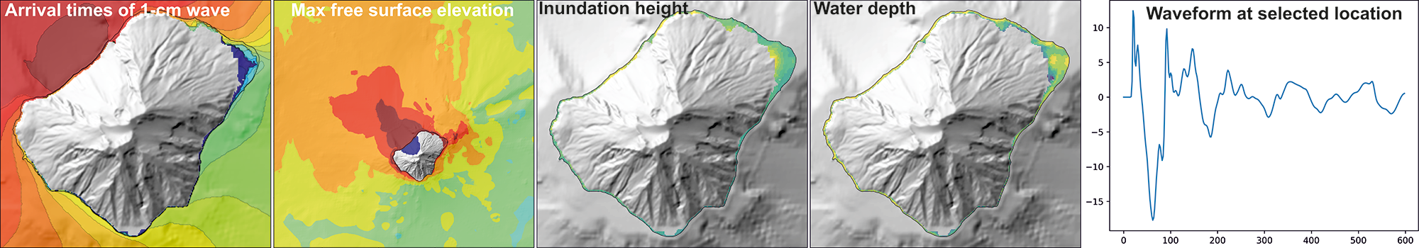
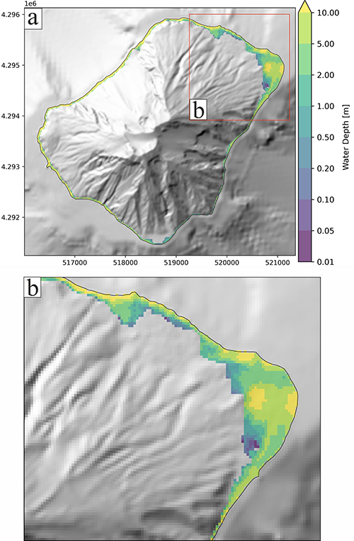
For each scenario, maps of the maximum wave height above sea level, arrival times of the first positive peak, inundation height above the ground and water depth are provided, together with the waveforms at selected sampling points, including those of the two sensor-equipped buoys installed offshore the Sciara del Fuoco. A subset of the simulations of this database has been used to develop probabilistic tsunami inundation maps in de’ Michieli Vitturi et al. (submitted), whose approach of development has been described in Tadini et al. (submitted) and de’ Michieli Vitturi et al. (submitted). The simulations have been developed within the “Convenzione Attuativa per il potenziamento delle attività di servizio, Task 2.2” in the framework of “Accordo Quadro DPC-INGV 2022-2025”. This database does not necessarily represent official views and policies of the Dipartimento della Protezione Civile.
REFERENCES
- Cerminara M., Esposti Ongaro T., De’ Michieli Vitturi M., Tadini A., Trolese M., Fornaciai A., Nannipieri L., Rodriguez Galvez J. F. (2024). Simulated scenarios of volcanic mass movements and associated tsunamis at Stromboli (Aeolian archipelago, Tyrrhenian sea, Italy). version 1 [Data set]. Istituto Nazionale di Geofisica e Vulcanologia (INGV). https://doi.org/10.13127/stromboli/sciara_del_fuoco_tsunami
- Chiocci F. L., Ridente D. (2011). Regional-scale seafloor mapping and geohazard assessment. The experience from the Italian project MaGIC (Marine Geohazards along the Italian Coasts). Marine Geophysical Research 32(1–2), 13–23. https://doi.org/10.1007/s11001-011-9120-6
- de’ Michieli Vitturi M., Tadini A., Bevilacqua A., Rodriguez Gàlvez J. F., Cerminara M., Esposti Ongaro T., Neri A., Trolese M., Macías J., Castro M. J., Escalante C., Ortega S., González-Vida J. M. (2026). Simulated scenarios of volcanic mass movements and associated tsunamis at Stromboli (Aeolian archipelago, Tyrrhenian sea, Italy) – version 2, simulations with 10-m resolution topo-bathymetry. [Dataset]. INGV Ufficio Dati.
- de’ Michieli Vitturi M., Tadini A., Bevilacqua A., Rodriguez Gàlvez J. F., Cerminara M., Esposti Ongaro T., Neri A., Trolese M., Macías J., Castro M. J., Escalante C., Ortega S., González-Vida J. M., Lorito S. (submitted). Probabilistic tsunami hazard assessment at Stromboli volcano: 2. New simulation database and probabilistic inundation maps and curves.
- Di Traglia F., Calvari S., D’Auria L., Nolesini T., Bonaccorso A., Fornaciai A., Esposito A., Cristaldi A., Favalli M., Casagli N. (2018). The 2014 Effusive Eruption at Stromboli: New Insights from In Situ and Remote‐Sensing Measurements. Remote Sens. 10, 2035, https://doi.org/10.3390/rs10122035
- Esposti Ongaro T., de’ Michieli Vitturi M., Cerminara M., Macías J., Castro M.J., Ortega S., & González-Vida, J.M. (2021). Modeling Tsunamis Generated by Submarine Landslides at Stromboli Volcano (Aeolian Islands, Italy): A Numerical Benchmark Study. Frontiers in Earth Science, 9(May), 1–21. https://doi.org/10.3389/feart.2021.628652
- Esposti Ongaro T., Cerminara M., de’ Michieli Vitturi M., Tadini A., Trolese M., Fornaciai A., Nannipieri L., Calusi B., Macías J., Castro M.J., Escalante C., Ortega S., González-Vida J.M., Rodriguez Galvez J.F. (2025) Modeling and numerical simulation of volcanic mass movements and associated tsunamis at Stromboli (Aeolian archipelago, Tyrrhenian sea, Italy). Frontiers in Earth Science, 13:1548961. https://doi.org/10.3389/feart.2025.1548961
- Macías J., Escalante C., Castro M.J. (2021). Multilayer-HySEA model validation for landslide-generated tsunamis – Part 2: Granular slides. Natural Hazards and Earth System Sciences, 21(2), 791–805. https://doi.org/10.5194/nhess-21-791-2021
- Macías J., Escalante C., Castro M.J. (2021). Multilayer-HySEA model validation for landslide-generated tsunamis – Part 2: Granular slides. Natural Hazards and Earth System Sciences, 21(2), 791–805. https://doi.org/10.5194/nhess-21-791-2021
- MASE (2013). DTM LiDAR con risoluzione a terra 1 metro – Regione Sicilia, Geoportale Nazionale, Ministero dell’Ambiente e della Sicurezza Energetica, http://www.pcn.minambiente.it
- Tadini A., Bevilacqua A., de’ Michieli Vitturi M., Bonilauri E., Harris A., Cerminara M., Esposti Ongaro T., Neri A., Paris R., Pistolesi M., Trolese M., Rodriguez Gàlvez J. F., Andronico D., Bertagnini A., Calvari S., Casalbore D., Cassidy M., Civico R., Del Bello E., Di Roberto A., Fornaciai A., Grezio A., Gurioli L., Harbitz C. B., Lacanna G., Løvholt F., Marani M., Pompilio M., Ricci T., Rosi M., Sandri L., Urgeles R., Voloschina M. (submitted). Probabilistic tsunami hazard assessment at Stromboli volcano: 1. Review of historical sources and expert elicitation findings.
Devi effettuare l'accesso per postare un commento.