


2004-05 Mt. Etna compound lava flow field: orthophotos and topography
Alessandro Fornaciai1, Daniele Andronico2, Massimiliano Favalli1, Letizia Spampinato2, Stefano Branca2, Luigi Lodato2, Alessandro Bonforte2, Luca Nannipieri1
1Istituto Nazionale di Geofisica e Vulcanologia, Sezione di Pisa, via Cesare Battisti 53, 56125 Pisa, Italy.
2Istituto Nazionale di Geofisica e Vulcanologia, Osservatorio Etneo, Sezione di Catania, Piazza Roma, 2 – 95125 Catania, Italy.
Corresponding author: Alessandro Fornaciai (alessandro.fornaciai@ingv.it)
DESCRIPTION
The 2004-05 lava field evolution was reconstructed using technologies, data and methods spanning from remote to on-situ techniques, from active to passive sensors, from mono- to multi-view photogrammetry, from digital terrain modeling to GIS analysis. In details, this dataset contains:
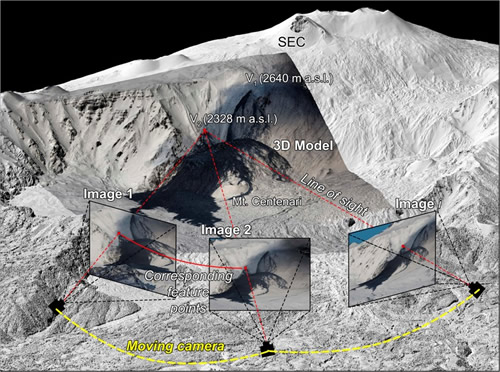
- Single optical and thermal images collected during the eruption and elaborated following the principles of single-image photogrammetry using both Pic2Map QGIS plugin (Produit et al., 2016) and an implemented ad-hoc code to obtain orthorectified images of the lava during its emplacement;
- LiDAR data acquired soon after the onset of the eruption and after its end (i.e. on 16 September 2004 and 29 September 2005, Favalli et al., 2009);
- A DEM of the lava field when it was active using multi-view photogrammetry methods starting from a set of optical and thermal images collected during the eruption.
REFERENCES
- Fornaciai A., Andronico D., Favalli M., Spampinato L., Branca S., Lodato L., Bonforte A., Nannipieri L. The 2004-05 Mt. Etna compound lava flow field: a retrospective analysis by combining remote and field methods. Submitted to Journal of Gephysical Research, Solid Earth.
- Favalli, M., Fornaciai, A., & Pareschi, M. T. (2009), LIDAR strip adjustment: Application to volcanic areas. Geomorphology, 111(3-4), 123-135. Produit, T., Ingensand, J., & Milani, G. (2016), QGIS plugin or web app? Lessons learned in the development of a 3D georeferencer (No. e2243v2). PeerJ Preprints.
Devi effettuare l'accesso per postare un commento.