Simulated scenarios of volcanic mass movements and associated tsunamis at Stromboli (Aeolian archipelago, Tyrrhenian sea, Italy)

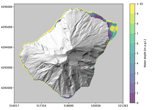
The map illustrates water depth in meters above ground level.
Creative commons license: Attribution 4.0 International (CC BY 4.0)
Scenarios list (csv file)
Scenarios data (zip file)
Matteo Cerminara1, Tomaso Esposti Ongaro1, Mattia de’ Michieli Vitturi1, Alessandro Tadini1, Matteo Trolese1, Alessandro Fornaciai1, Luca Nannipieri1, Benedetta Calusi2, Jorge Macìas-Sanchez3, Manuel J. Castro Díaz3, Sergio Ortega Acosta3, José M. González-Vida3, Cipriano Escalante3 and Juan F. Rodriguez-Galvez1-3
1) Istituto Nazionale di Geofisica e Vulcanologia, Pisa, Italy
2) Dipartimento di Matematica, Università degli Studi di Firenze, Italy
3) EDANYA Group, Universidad de Málaga, Spain
How to cite
Cerminara M., Esposti Ongaro T., De’ Michieli Vitturi M., Tadini A., Trolese M., Fornaciai A., Nannipieri L., Rodriguez Galvez J. F. (2024). Simulated scenarios of volcanic mass movements and associated tsunamis at Stromboli (Aeolian archipelago, Tyrrhenian sea, Italy). version 1 [Data set]. Istituto Nazionale di Geofisica e Vulcanologia (INGV). https://doi.org/10.13127/stromboli/sciara_del_fuoco_tsunami
Description
We present a set of simulations of volcanic mass movement scenarios and the subsequent tsunami generation, propagation and inundation on the Stromboli shores (Esposti Ongaro et al., 2021). Scenarios are produced by using Multilayer-HySEA, a multilayer, depth-averaged non-hydrostatic numerical model able to simulate the dynamics of granular avalanches, their interaction with the sea, and the generation and propagation of the water waves (Macías et al., 2021). Wave dispersion over complex bathymetries is captured by the shallow-water model by using 3 layers for the water phase. Simulation scenarios are made available for future hazard and risk assessment studies (Selva et al., 2021).
6 landslides volumes, ranging from 3×10⁶ and 30×106 m3, and 11 vertical elevations from 500 m above to -580 m under the sea level are analyzed, to encompass the range hypothesized for the 2002 event at Stromboli, taken as a reference scenario. Densities of 1666, 2000 and 2500 kg/m3 (i.e. density contrasts of 0.6, 0.5, and 0.4, with respect to water density) are explored, for a total of 6×11×3=198 scenarios. For each scenario, maps of the maximum wave height above sea level, arrival times of the first positive peak, and the inundation level above the ground and the sea level are provided, together with the waveforms at selected sampling points, including those of the two sensor-equipped buoys installed offshore the Sciara del Fuoco.
References
- Esposti Ongaro T., de’ Michieli Vitturi M., Cerminara M., Macías J., Castro M.J., Ortega S., & González-Vida, J.M. (2021). Modeling Tsunamis Generated by Submarine Landslides at Stromboli Volcano ( Aeolian Islands , Italy ): A Numerical Benchmark Study. Frontiers in Earth Science, 9(May), 1–21. https://doi.org/10.3389/feart.2021.628652
- Macías J., Escalante C., & Castro M.J. (2021). Multilayer-HySEA model validation for landslide-generated tsunamis – Part 2: Granular slides. Natural Hazards and Earth System Sciences, 21(2), 791–805. https://doi.org/10.5194/nhess-21-791-2021
- Selva J., Amato A., Armigliato A., Basili R., Bernardi F., Brizuela B., Cerminara M., de’ Michieli Vitturi M., Di Bucci D., Di Manna P., Esposti Ongaro T., Lacanna G., Lorito S., Løvholt F., Mangione D., Panunzi E., Piatanesi A., Ricciardi A., Ripepe M., Romano F., Santini M., Scalzo A., Tonini R., Volpe M., Zaniboni F. (2021). Tsunami risk management for crustal earthquakes and non-seismic sources in Italy. La Rivista Del Nuovo Cimento. https://doi.org/10.1007/s40766-021-00016-9


Devi effettuare l'accesso per postare un commento.