


Multi-year Digital Surface Models (2010–2022) of La Fossa Cone: High-resolution Dataset of the North-Western Sector (Vulcano Island, Italy)
Nannipieri L.1, M. Favalli1, F. Di Traglia2, A. Fornaciai1*
1Istituto Nazionale di Geofisica e Vulcanologia, Sezione di Pisa, Via Cesare Battisti, 53 – 56125 Pisa, 56125 Pisa, Italy.
2Istituto Nazionale di Geofisica e Vulcanologia, Osservatorio Vesuviano – Sezione di Napoli, Via Diocleziano, 328, 80124, Napoli, Italy
*Corresponding author
Abstract
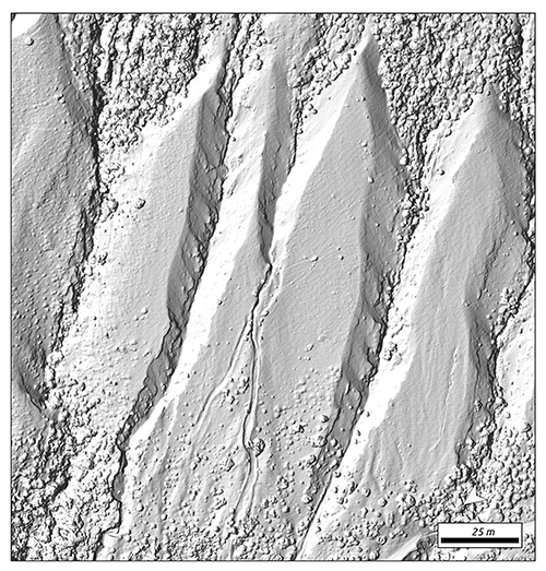
The Island of Vulcano is the emerging portion of a composite volcanic edifice belonging to the Aeolian volcanic archipelago in the southern Tyrrhenian Sea. The remobilization of loose volcaniclastic material from La Fossa cone, triggered by heavy rainfall and the subsequent generation of small debris flows, represents a recurrent hazard on the island. Gravitational and erosive processes, mainly driven by rainfall, have formed several gully systems on the slopes of La Fossa. These systems significantly increase both surface runoff and downslope mass wasting. In order to reconstruct the geomorphometric evolution of the gully system in the north-western sector of La Fossa cone from 2010 to 2022, we carried out successive UAS surveys. This area is characterized by a large gully system and acts as the primary source for volcaniclastic debris flows that pose a potential threat to the island’s most populated areas.
We here make available the Multi-temporal Digital Surface Models generated from aerial photographs collected during the 2017, 2019, and 2022 surveys, as well as the LiDAR-derived DEM from 2010.
This multi-year dataset provides a high-resolution topographic record essential for quantifying sediment dynamics and slope reorganization over more than a decade. By offering a detailed view of the morphological changes within the NW gully system, these data serve as a fundamental tool for improving geohazard assessment and land-use planning in the most populated areas of Volcano Island.
How to cite:
Nannipieri L., Favalli M., Di Traglia F., Fornaciai A. (2026). Multi-year Digital Surface Models (2010–2022) of La Fossa Cone: High-resolution Dataset of the North-Western Sector (Vulcano Island, Italy) [Dataset]. Istituto Nazionale di Geofisica e Vulcanologia (INGV). https://doi.org/10.13127/vulcano-2017-2022-uas-survey
Devi effettuare l'accesso per postare un commento.