


Environmental and Oceanographic Conditions at the Continental Margin of the Central Basin, Northwestern Ross Sea (Antarctica) Since the Last Glacial Maximum
Torricella f., R. Melis, E. Malinverno, G. Fontolan, M. Bussi, L. Capotondi, P. Del Carlo, A. Di Roberto, A. Geniram, G. Kuhn, B.K. Khim, C. Morigi,
B. Scateni and E. Colizza
Geosciences, 11, 155, https://doi.org/10.3390/geosciences11040155
Abstract
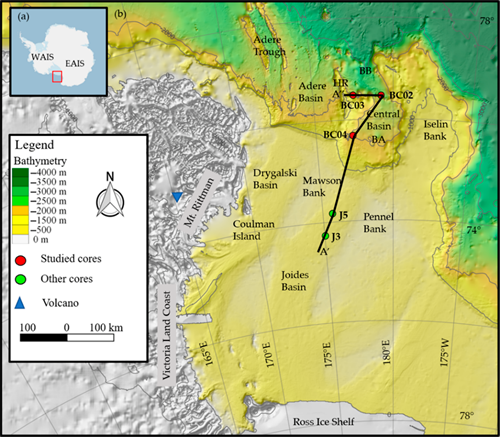
The continental margin is a key area for studying the sedimentary processes related to the advance and retreat of the Ross Ice Shelf (Antarctica); nevertheless, much remains to be investigated. The aim of this study is to increase the knowledge of the last glacial/deglacial dynamics in the Central Basin slope–basin system using a multidisciplinary approach, including integrated sedimentological, micropaleontological and tephrochronological information. The analyses carried out on three box cores highlighted sedimentary sequences characterised by tree stratigraphic units. Collected sediments represent a time interval from 24 ka Before Present (BP) to the present time. Grain size clustering and data on the sortable silt component, together with diatom, silicoflagellate and foraminifera assemblages indicate the influence of the ice shelf calving zone (Unit 1, 24–17 ka BP), progressive receding due to Circumpolar Deep Water inflow (Unit 2, 17–10.2 ka BP) and (Unit 3, 10.2 ka BP–present) the establishment of seasonal sea ice with a strengthening of bottom currents. The dominant and persistent process is a sedimentation controlled by contour currents, which tend to modulate intensity in time and space. A primary volcanic ash layer dated back at around 22 ka BP is correlated with the explosive activity of Mount Rittmann.
Devi effettuare l'accesso per postare un commento.