


Sharpening our view of active Earth processes with high resolution topography
| 19 Ottobre 2017 | ore 11.30 | Prof. J Ramón Arrowsmith – School of Earth and Space Exploration, Arizona State University | INGV Sezione di Pisa – Sala Seminari
Abstract
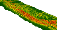
Displacements of topography and subsequent surface process responses from earthquakes, volcanic phenomena, and other geomorphic events have meters of magnitude typically and occur across zones 10s to 1000s of meters wide and as much as 100s of km long. Given these spatial constraints, it is essential to have the right capability to measure the resultant features at the appropriate fine scale. High resolution topography samples the ground surface at least once per square meter and has decimeter local or preferably global accuracy. Analyses of high resolution topography in the study of active Earth processes can be divided into several classes: feature mapping, reconstructing surface changes, investigating geomorphic responses to large displacements, and differencing of repeat surveys. This talk will mostly emphasize active faulting but will have relevance for volcanic and other geomorphic phenomena.