


Multitemporal and Multisensor InSAR Analysis for Ground Displacement Field Assessment at Ischia Volcanic Island (Italy)
Beccaro L., C. Tolomei, R. Gianardi, V. Sepe, M. Bisson, L. Colini, R. De Ritis and C. Spinetti.
Remote Sensing, https://doi.org/10.3390/rs13214253
Abstract
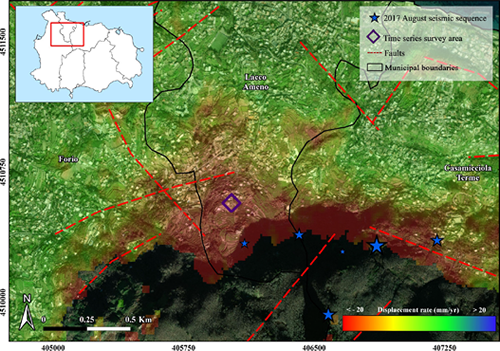
Volcanic islands are often affected by ground displacement such as slope instability, due to their peculiar morphology. This is the case of Ischia Island (Naples, Italy) dominated by the Mt. Epomeo (787 m a.s.l.), a volcano-tectonic horst located in the central portion of the island. This study aims to follow a long temporal evolution of ground deformations on the island through the interferometric analysis of satellite SAR data. Different datasets, acquired during Envisat, COSMO-SkyMed and Sentinel-1 satellite missions, are for the first time processed in order to obtain the island ground deformations during a time interval spanning 17 years, from November 2002 to December In detail, the multitemporal differential interferometry technique, named small baseline subset, is applied to produce the ground displacement maps and the associated displacement time series. The results, validated through the analysis and the comparison with a set of GPS measurements, show that the northwestern side of Mt. Epomeo is the sector of the island characterized by the highest subsidence movements (maximum vertical displacement of 218 mm) with velocities ranging from 10 to 20 mm/yr. Finally, the displacement time series allow us to correlate the measured ground deformations with the seismic swarm started with the Mw 3.9 earthquake that occurred on 21 August 2017. Such correlations highlight an acceleration of the ground, following the mainshock, characterized by a subsidence displacement rate of 0.12 mm/day that returned to pre-earthquake levels (0.03 mm/day) after 6 months from the event.
Devi effettuare l'accesso per postare un commento.