



Ballistic projectile hazard of major explosions and paroxysms at Stromboli (Italy) with uncertainty quantification – Part 2: Conditional and temporal probability maps
This pair of manuscripts (2025-6539 and 6540) constitute a significant step forward in the modelling of ballistic hazards from volcanic explosive activity at a volcano that has an unparalleled dataset (collated by these authors, building on previous work) and where there is considerable tourist activity particularly in the summer months (with hiking trails – for which this paper assesses the hazard – going to the active summit craters). There is therefore both considerable scientific interest in this paper (in the methods and moving the field forward) but also wider public interest.
Bevilacqua A., A. Neri, P. Landi, P. Del Carlo, M. Pompilio, P. Baxter (2026).
Natural Hazards and Earth System Sciences, 26, 4503–4527. https://doi.org/10.5194/nhess-26-4503-2026
Abstract
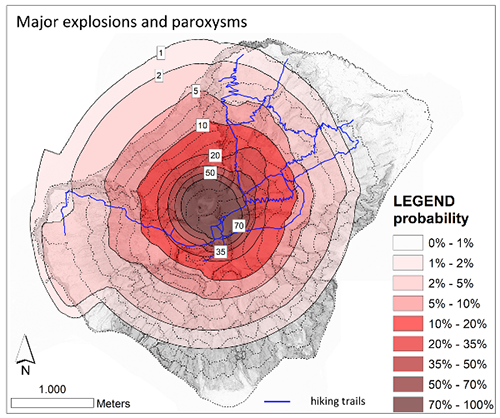
This study presents the first probability hazard maps of the areas potentially affected by ballistic fallout from major explosions and paroxysms at Stromboli, based on mathematical analyses of the extensive historical and recent records of its explosive activity. This novel approach develops and integrates three statistical models that describe ballistic fallout patterns under different assumptions and considering the associated uncertainty. Model 1 mirrors the areas observed to be affected in the past, whereas Models 2 and 3 address data under-sampling and morphological/dynamics changes assuming independency between ballistic distance and dispersal direction. By combining these models, robust and conservative ballistic fallout hazard maps are produced for major explosions and paroxysms, and for the two categories combined together by assuming a relative proportion. The new combined maps highlight the most exposed areas of the island and quantify the probability of being affected in the case of a major explosion or paroxysm. For instance, the NE trails at 600 m would have ≈25% probability of ballistic fallout, while the Labronzo trail ≈8% and 5% probability at 400 and 290 m, respectively; the entire village of Ginostra would be affected with ≈3% probability. Combining such maps with a temporal model of occurrence of the events, first probability maps of ballistic fallout in the next 10 and 50 years are presented. Results are limitedly influenced by mapping uncertainties and by the assumed proportion between major explosions and paroxysms. These findings open the way to individual and societal risk assessments for this phenomenon at Stromboli.
Devi effettuare l'accesso per postare un commento.