Divulgazione e didattica
Sei qui: Home > News > Control of gravitational potentialenergy on the distribution of off‐riftvolcanic activity in the Turkanadepression, East African rift

Control of gravitational potentialenergy on the distribution of off‐riftvolcanic activity in the Turkanadepression, East African rift

Geophysical Research Letters, Corti et al. 2025 - Figure 1
(a) Faults, seismicity, and Pleistocene-Holocene volcanic vents in the Turkana Depression superimposed on a SRTM (Nasa Shuttle Radar Topography Mission) digital elevation model. Seismicity is from U.S. Geological Survey National Earthquake Information Center catalog (1900 to present; citation needed for the NEIC catalog, https://earthquake.usgs.gov/earthquakes/search/). Green dots illustrate in-axis volcanoes (Em: Emuruangogolak, Ba: Barrier, CI: Central Island, Ko: Korath range, Na: Namarunu, Si: Silali, SI: South Island); black dots illustrate off-rift volcanic fields (As: Asie; DD: Dilo-Dukana; HH: Hurri Hills; Ma: Marsabit; Me: Mega). LT: Lake Turkana; RR: Ririba Rift. Inset in the bottom left corner illustrate the present-day plate kinematics of the East African Rift. Black arrows show relative motions with respect to a stable Nubian reference frame according to the best fit model of Saria et al. (2014). Black dashed lines indicate plate and microplate boundaries from Stamps et al. (2021). AR: Arabian plate; ER: Ethiopian Rift; KR: Kenyan Rift; NU: Nubian plate; SO: Somalian plate; RO: Rovuma microplate; VI: Victoria microplate. (b, c) Details of vent distribution in the different volcanic fields, illustrated as ellipses that are derived by applying Principal Component Analysis (PCA; Mazzarini et al., 2016) to the original data sets (vent location in UTM coordinates -WGS84 datum, available as open access database (Isola et al., 2024)). PCA describes the ellipse containing 95% of the data set and gives the azimuth of each ellipse’s major axis. Numbers below the labels of the volcanic field name indicate the orientation of the ellipse’s maximum axis. (d) Distribution of tectonic and volcanic activity across the Turkana Depression (location of cross-section in panel a). The red line (“Max extension”) indicates the area of maximum active extension and the modern-day plate boundary constrained from the synthesis of seismic and geodetic results by Musila et al. (2023). VE: vertical exaggeration.

Corti G., A. Muluneh, D.S. Stamps, D. Keir, I. Isola, F. Mazzarini, S. Brune, D. Maestrelli (2025).
Geophysical Research Letters, 52. https://doi.org/10.1029/2024GL114277

Abstract

The distribution and alignment of volcanism in continental rifts is controlled by regional
extensional stresses modulated by several factors such as structural inheritance, volcano edifice loading, and rift
architecture. These interactions result in complex characteristics of rift‐related volcanic features, which may be
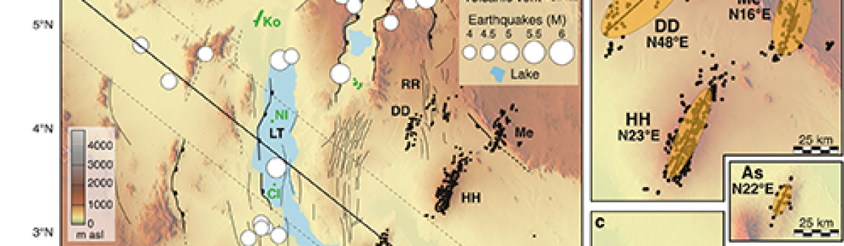
difficult to interpret considering the different controlling processes. The Turkana Depression (East Africa)
exemplifies these complexities, showing an anomalous location of volcanic fields (outside the area of ongoing
extension), with variable vent orientation. We analyze vent distribution in the Turkana Depression and calculate
the stresses resulting from Gravitational Potential Energy (GPE). Our results show that West to East variations
in topography and (subordinately) crustal thickness give rise to extensional GPE‐related stresses East of Lake
Turkana, where recent off‐rift volcanism is localized. Within each different volcanic field, local GPE‐related
stresses control the arrangement of volcanic vents, which therefore do not respond to the regional (plate motion‐
driven) stress field.