A new photographic dataset of the coseismic geological effects originated by the Mw5.9 Visso and Mw6.5 Norcia earthquakes (26th and 30th October 2016, Central Italy)
Emergeo Working Group (2017).
Miscellanea INGV, Vol. 38.
Introduction
This paper follows a previous issue of Miscellanea INGV [Emergeo Working Group, 2017] dedicated to the seismo-geological effects produced by the 24 August 2016 Amatrice earthquake. In this work, we present a collection of pictures showing the geological effects produced on either the natural or the built environment by the late October 2016 Visso and Norcia earthquakes in Central Italy. Two months after the beginning of the seismic sequence with the occurrence of the Mw6.0 Amatrice mainshock, on the 26 October a new earthquake with Mw5.9 occurred 25 km to the north, near the village of Visso. Finally, on the 30 October, the largest shock of the sequence with Mw6.5 struck the area between the two previous events, near Norcia. The October earthquakes occurred along the ~NW-striking, SW-dipping, ~30 km-long fault system known as the Mt. Vettore – Mt. Bove fault system (VBFS). Both the 26 October earthquake and, most significantly, the 30 October mainshock generated new and larger ruptures at the surface, often exceeding those originated by the August event. After the three mainshocks a total of almost 30 kilometers of surface faulting were mapped between the villages of Cupi to the north and Arquata del Tronto to the south. The coseismic ruptures were observed along several fault planes belonging to the VBFS, both on sinthetic and on antithetic splays. Figure 1 shows the map of the most prominent surface ruptures observed in the field, along with the location of the main shocks of the seismic sequence.
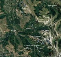
Following the October events, the Emergeo Working Group surveyed a ~500 km2 large area, collecting more than 7000 observations of surface coseismic effects such as fractures, ruptures, landslides, and other secondary effects related to shaking (e.g. mud volcanism, liquefaction, clast extrusions, soil remobilization, etc.). Most of the coseismic geological effects were collected through field survey along with additional observations achieved by means of helicopter flights and helikite (helium balloon). About 15000 photographs were shot during the survey. This atlas presents a wide selection of photos (about one hundred pictures) of coseismic ground effects observed over an area extending ~30 km by ~10 km in the NW-SE and in the NE-SW directions, respectively. Each picture reports information on the type of effect, the site of observation, and the geographical coordinates (decimal degrees). Figure 2 shows the general location
map of the photographs. Further information on the 2016-2017 Central Italy seismic sequence and on the associated coseismic effects can be retrieved in: Chiaraluce et al. [2017], Pucci et al. [2017], and Civico et al. [2017]. A collection of earthquake-induced effects, for both the Visso and Norcia events (with a specific focus on landslides), is presented also by Gruppo di Lavoro CERI [2016a and b].


