


Catching Geomorphological Response to Volcanic Activity on Steep Slope Volcanoes Using Multi-Platform Remote Sensing
Di Traglia F., A. Fornaciai, M. Favalli, T. Nolesini, N. Casagli (2020).
Remote Sensing, 12/3, 438; https://doi.org/10.3390/rs12030438.
Abstract
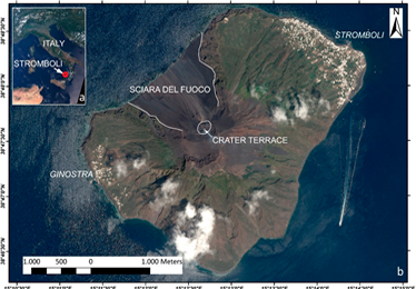
The geomorphological evolution of the volcanic Island of Stromboli (Italy) between July 2010 and June 2019 has been reconstructed by using multi-temporal, multi-platform remote sensing data. Digital elevation models (DEMs) from PLÉIADES-1 tri-stereo images and from Light Detection and Ranging (LiDAR) acquisitions allowed for topographic changes estimation. Data were comprised of high-spatial-resolution (QUICKBIRD) and moderate spatial resolution (SENTINEL-2) satellite images that allowed for the mapping of areas that were affected by major lithological and morphological changes. PLÉIADES tri-stereo and LiDAR DEMs have been quantitatively and qualitatively compared and, although there are artefacts in the smaller structures (e.g., ridges and valleys), there is still a clear consistency between the two DEMs for the larger structures (as the main valleys and ridges). The period between July 2010 and May 2012 showed only minor changes consisting of volcanoclastic sedimentation and some overflows outside the crater. Otherwise, between May 2012 and May 2017, large topographic changes occurred that were related to the emplacement of the 2014 lava flow in the NE part of the Sciara del Fuoco and to the accumulation of a volcaniclastic wedge in the central part of the Sciara del Fuoco. Between 2017 and 2019, minor changes were again detected due to small accumulation next to the crater terrace and the erosion in lower Sciara del Fuoco.
Devi effettuare l'accesso per postare un commento.