


Identification of leveled archeological mounds (Höyük) in the alluvial plain of the Ceyhan River (Southern Turkey) by satellite remote-sensing analyses
Bini M., I. Isola, G. Zanchetta, A. Ribolini, A. Ciampalini, I. Baneschi, D. Mele, A.L. D’Agata (2018).
Remote sensing, 10/2, 241, ISSN: 2072-4292, doi: 10.3390/rs10020241
Abstract
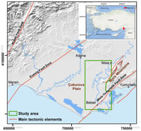
The alluvial plain of the Ceyhan River (SE Turkey) has been populated since the Neolithic. In 1954, Marjory Veronica Seton-Williams described for this area several archeological mounds (höyük), which are the remains of ancient settlements. Today, according to the archeological research carried out in the area, some of these mounds result to have been leveled by agricultural activities. In this work, we identified many color anomalies by low-cost remote-sensing analyses of satellite images. We checked the nature of these anomalies in a dedicated survey and we found a good correspondence between color anomalies and archeological remains consistent with leveled höyük. We compared the grain size and chemical characteristics of the soil collected inside the color anomalies with the soil collected in other areas of the alluvial plain. We found irrelevant differences in grain-size characteristics, but a higher content of CaCO3 in soils collected inside the anomalies with respect to those collected outside. Therefore, the content of CaCO3 could be considered the feature that makes the color anomalies visible. The reason for this higher content of CaCO3 is related to the anthropogenic material used in the different phases of höyük growth. This work suggests a low-cost analysis useful for rapid identification and preservation of archeological information on the history of Mediterranean settlement.