


Geomorphology of the Ceyhan River lower plain (Adana Region, Turkey)
Isola I., M. Bini, A. Ribolini, G. Z. & A. Lucia D’Agata (2017).
Journal of Maps, 13/2, 133-141 doi:http://dx.doi.org/10.1080/17445647.2016.1274684
Abstract
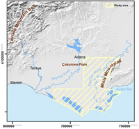
We present a geomorphological map (Main Map) of the lower plain of the Ceyhan River (Adana province, Turkey). Data from three field campaigns and remote sensing observations were managed in a GIS to produce a 1:25,000 scale map. The area, mostly formed by alluvial sediments, is characterized by intense fluvial dynamics with superimposed agricultural activity. Erosional processes prevail on rocky ridges partially bordering the plain on the north-eastern side. The alluvial plain is flanked by large alluvial fans on its eastern side, whereas the western limit consists of a smoothed and undistinguishable watershed. Alluvial and deltaic deposits close to the river mouth are bordered southward by nested coastal dunes, lagoons, swamps and marshes punctuating the coastal belt. This area was an important historical site, as documented by evidence of settlements from the Neolithic. The map is a useful tool to support further archaeological research.
http://www.tandfonline.com/doi/full/10.1080/17445647.2016.1274684