


Lava fow hazard at Fogo Volcano, Cape Verde
Richter N., M. Favalli, E. de Zeeuw-van Dalfsen, A. Fornaciai, R. Fernandes, N. Perez Rodriguez, J. Levy, S. S. Victoria, T. R. Walter (2016).
Natural Hazards and Earth System Science, 16, 1925–1951, doi:10.5194/nhess-16-1925-2016.
Abstract
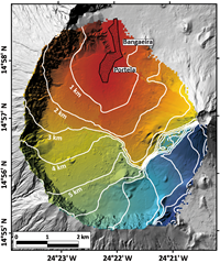
Lava flow simulations help to better understand volcanic hazards and may assist emergency preparedness at active volcanoes. We demonstrate that at Fogo Volcano, Cabo Verde, such simulations can explain the 2014–2015 lava flow crisis and therefore provide a valuable base to better prepare for the next inevitable eruption. We conducted topographic mapping in the field and a satellite-based remote sensing analysis. We produced the first topographic model of the 2014–2015 lava flow from combined terrestrial laser scanner (TLS) and photogrammetric data. This high-resolution topographic information facilitates lava flow volume estimates of 43.7 ± 5.2 × 10⁶ m3 from the vertical difference between pre- and posteruptive topographies. Both the pre-eruptive and updated digital elevation models (DEMs) serve as the fundamental input data for lava flow simulations using the well-established DOWNFLOW algorithm. Based on thousands of simulations, we assess the lava flow hazard before and after the 2014–2015 eruption. We find that, although the lava flow hazard has changed significantly, it remains high at the locations of two villages that were destroyed during this eruption. This result is of particular importance as villagers have already started to rebuild the settlements. We also analysed satellite radar imagery acquired by the German TerraSAR-X (TSX) satellite to map lava flow emplacement over time. We obtain the lava flow boundaries every 6 to 11 days during the eruption, which assists the interpretation and evaluation of the lava flow model performance. Our results highlight the fact that lava flow hazards change as a result of modifications of the local topography due to lava flow emplacement. This implies the need for up-to-date topographic information in order to assess lava flow hazards. We also emphasize that areas that were once overrun by lava flows are not necessarily safer, even if local lava flow thicknesses exceed the average lava flow thickness. Our observations will be important for the next eruption of Fogo Volcano and have implications for future lava flow crises and disaster response efforts at basaltic volcanoes elsewhere in the world.