


Lidar surveys reveal eruptive volumes and rates at Etna, 2007–2010
Behncke B., A. Fornaciai, M. Neri, M. Favalli, G. Ganci, F. Mazzarini (2016).
Geophysical Research Letters, 43/9, 4270–4278, doi: 10.1002/2016GL068495
Abstract
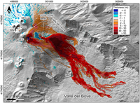
The quantification of eruptive activity represents one major challenge in volcanology. Digital comparison of lidar-based elevation models of Etna (Italy) was made to quantify the volumes of volcanics emitted in 2007–2010. During this period, Etna produced several summit paroxysms followed by a flank eruption. We integrated the total volume difference resulting from the subtraction of the 2007 and 2010 digital elevation models with volumes of eruptive products based on field and aerial surveys to attribute volumes with hitherto unrealized precision to poorly constrained eruptions. The total erupted volume of 2007–2010 is >86 × 106 m3, most (~74 × 106 m3) of which is made up by the lava flows of the 2008–2009 flank eruption. The survey also reveals the high lava volume (5.73 × 10⁶ m3) and average eruption rate (~400 m3 s−1) of the 10 May 2008 paroxysm, whose flow front stopped 6.2 km from the vent, not far from the town of Zafferana Etnea.
http://onlinelibrary.wiley.com/doi/10.1002/2016GL068495/abstract