


New insight into the 2011-2012 unrest and eruption of El Hierro Island (Canary Islands) based on integrated geophysical, geodetical and petrological data
Stavros Meletlidis, Alessio Di Roberto, Itahiza Domínguez Cerdeña, Massimo Pompilio, Laura García-Cañada, Antonella Bertagnini, Maria Angeles Benito-Saz, Paola Del Carlo, Sergio Sainz-Maza Aparicio
Annals of Geophysics, 58, 5, doi:10.4401/ag-6754.
Abstract
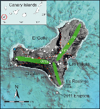
A shallow water eruption started on October 10, 2011, ~2 km south off the coast of El Hierro (Canary Islands, Spain). The eruption lasted about five months and ended by early March 2012. Three months of unrest preceded this event with more than 10,000 localized earthquakes and up to 6 cm of vertical ground deformation. In the Canary Islands, this is the first eruption to be monitored by the network of Instituto Geográfico National (IGN) since the very beginning of the seismic unrest. This provided unprecedented time series that include geophysical (seismic and gravimetric), geodetic, geochemical and petrological data. In this work we discuss and interpret these data in order to describe the mechanisms of 2011-2012 El Hierro eruption, including ascent from magmatic source, a crustal storage, and the final intrusion in the South Rift before the eruption. Our research approach provides a multidisciplinary view of the dynamics of magma ascent and improves previous interpretations formulated during or shortly after the end of the eruption. According to our results, a major intrusion occurred beneath and around preexisting high-density magmatic bodies, localized at depth below the central part of the island. After a failed attempt to reach the surface through a low fractured zone located below the central-northern part of the island, the ascending magma finally found its way nearby the El Hierro South Rift Zone and erupted off the coast of La Restinga village, 350 m below sea level. The eruption was fed by the ascent of an important volume of material from the upper mantle that was emplaced near the crust-mantle boundary and progressively tapped during the eruption.
http://www.annalsofgeophysics.eu/index.php/annals/article/view/6754