


Rapid updating and improvement of airborne LIDAR DEMs through ground based SfM 3D modeling of volcanic features
Kolzenburg S., M. Favalli, A. Fornaciai, I. Isola, A. Harris, L. Nannipieri, D. Giordano (2016)
Transactions on Geoscience and Remote Sensing, 54, 11, 6687-6699, doi: 10.1109/TGRS.2016.2587798
Abstract
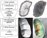
We present a workflow to create, scale, georeference, and integrate digital elevation models (DEMs) created using open-source structure-from-motion (SfM)multiview stereo (MVS) software into existing DEMs (as derived from the light detection and ranging data in the presented cases). The workflow also maps the root-mean-square error between the base DEM and the SfM surface model. This allows DEM creation from field-based surveys using consumer-grade digital cameras with open-source and custom-built software. We employ this workflow on three examples of different scales and morphology: 1) a scoria cone on Mt. Etna; 2) a lava channel on Mauna Ulu (K¯ılauea); and 3) a flank collapse scar on Mt. Etna. This represents a new approach for rapid low-cost construction and updating of existing DEMs at high temporal and spatial resolutions and for areas of up to several thousand square meters. We assess the self-consistency of the method by comparison of DEMs of the same features, created from independent data sets acquired on the same day and from the same vantage points.We further evaluate the effect of grid cell size on the reconstruction error. This method uses existing DEMs as a georeferencing tool and can therefore be used in limited access and potentially hazardous areas as it no longer relies exclusively on control targets on the ground.