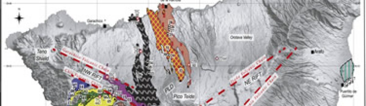
Figure 1. Bathymetric map of the study area with location of the sediment drifts and sediments cores (modified after Rebesco et al., 2013). Caricchi C., R. Giulia Lucchi, L. Sagnotti, P. Macrì, A. Di Roberto, P. Del Carlo, K. Husum, J. Sverre Laberg, C. Morigi (2019).Geochemistry, Geophysics, Geosystems,…
Archiviati
The web application AutoRate to decluster, to estimate completness of a catalog and seismicity rates of source zones
Informations used to evaluate the completeness. Francesco Martinelli e Carlo Meletti (2019).Rapporti Tecnici INGV, n. 406.http://editoria.rm.ingv.it/rapporti/2019/rapporto406/ Introduction During the process for assessing seismic hazard there are some recurring operations which can be automated, which are about analysing the input data elements. The recurring operations are based on standard procedures…
Making Linked Data more reliable with a failover server system: a case study with seismological data at INGV.
The network scenario in which operates the solution presented in this paper
Nannipieri L., S. Cacciaguerra, S. Mirenna, M. Locati, M. Marletta, E. Gucciardi (2019). Making Linked Data more reliable with a failover server system: a case study with seismological data at INGV, Annals of Geophysics, 62, DOI: https://doi.org/10.4401/ag-8050.
Landslide susceptibility mapping by remote sensing and geomorphological data: case studies on the Sorrentina Peninsula (Southern Italy)
Figure 1. Sorrentina Peninsula Geological map (modified after Apuzzo et al. 2013) Spinetti C., M. Bisson, C. Tolomei, L. Colini, A. Galvani, M. Moro, M. Saroli & V. Sepe (2019).GIScience & Remote Sensing, DOI: 10.1080/15481603.2019.1587891. Abstract The Sorrentina Peninsula is a densely populated area…
Aborted propagation of the Ethiopian rift caused by linkage with the Kenyan rift
Tectonic setting of the Turkana depression. a Quaternary faults, seismicity and Quaternary volcanoes in the Turkana depression and surrounding regions superimposed on a SRTM (NASA Shuttle Radar Topography Mission) digital elevation model (modified from ref. 17). Seismicity from USGS National Earthquake Information Center (NEIC) catalogue (https://earthquake.usgs.gov/earthquakes/search/); Quaternary volcanoes from the…
Volcanic threats to global society
The 1991 eruption of Mount Pinatubo in the Philippines, classified as VEI 6, cooled global climate by up to 0.7 °C for several years. Papale P., W. Marzocchi (2019).Science, 363/6433, 1275-1276, DOI: 10.1126/science.aaw7201. Eruzioni nel mondo, presentata la prima stima globale delle probabilità Un recente studio…
Devi effettuare l'accesso per postare un commento.