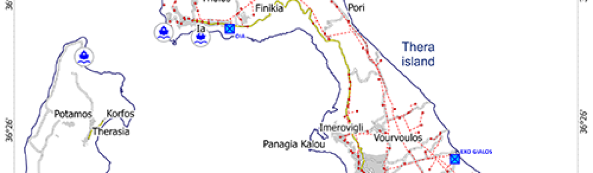
Geyer A., A. Di Roberto, J.L. Smellie, M. Van Wyk de Vries, K.S. Panter, A.P. Martin, J.R. Cooper, D. Young, M. Pompilio, P.R. Kyle, D. Blankenship, (2023).Journal of Volcanology and Geothermal Research, 444.https://doi.org/10.1016/j.jvolgeores.2023.107941 Abstract Over the past decades, significant efforts have been made to understand the…
News
High-resolution mapping and dispersion analyses of volcanic ballistics emitted during the 3rd July 2019 paroxysm at Stromboli
Geometry framework used for the analyses and including rings, sectors and reference elements. The number in bold black indicates the ring, and the number in bold red indicates the angular sector. The black circles (25 m of radius) represent the reference areas for analysing the variation of dispersion parameters along…
ANTARTIDE | Realizzato un Osservatorio Vulcanologico permanente
Video qui sul YT INGV – Ist. Nazionale di Geofisica e Vulcanologia ANTARTIDE | Realizzato un Osservatorio Vulcanologico permanente_Discesa ANTARTIDE | Realizzato un Osservatorio Vulcanologico permanente_Esterno ANTARTIDE | Realizzato un Osservatorio Vulcanologico permanente_Interno_IceCave Realizzato dall’Università…
Volcanic Early Warning Using Shannon Entropy: Multiple Cases of Study
Temporal evolution of the Shannon entropy before and after four lava fountain paroxysms of Mt. Etna during November 2013 all of them marked with vertical red lines. Green region indicates a decay bigger than the 70%. Decay at the moment of the eruption: 98.4%, 98.9%, 97.4%, and 95.1%. Rey-Devesa P., C.
Vents opening susceptibility map of the Colli Albani long dormant volcano
Figure 1. Schematic Geological map of the Colli Albani volcano derived from the 1:50,000 scale geodatabase of the Italian official Geological Map (ISPRA; Giordano, Benedetti, et al. 2010). Legend: (0) topographic caldera rim; (1a) Holocene alluvial and coastal deposits; (1b) undefined sedimentary rocks; (2) via dei Laghi maar complex (ca. 200 ka–Holocene);…
Historical explosive activity of Mount Melbourne Volcanic Field (Antarctica) revealed by englacial tephra deposits
(a) Map of the volcanoes in northern Victoria Land. The location of the studied outcrop is labelled with a red star whereas the location of the marine sediment core TR17-08 in Edisto Inlet (Di Roberto et al. 2023) and of the deep ice cores at Talos Dome and Styx…
Devi effettuare l'accesso per postare un commento.